

Aerial Evidence
On Scene Before It Disappears.
When an accident, injury, or site dispute happens in the Florida Panhandle, the scene starts changing the moment it's cleared. American Drone Team deploys FAA-certified pilots fast — so attorneys, investigators, and insurers get clear, defensible aerial documentation that stands up in court.
Why Attorneys Trust Us
FAA Part 107 Certified
Licensed commercial pilot
Veteran-Owned
Discipline you can rely on
Commercially Insured
$1M+ liability coverage
RAPID RESPONSE
Available 7 days a week
100%
FAA Compliant
$1M+
INSURED
7/7
DAYS AVAILABLE
FAA Part 107 Certified
Veteran-Owned & Operated
$1M+ Commercial Insurance
Aerial Evidence Deliverables
Florida Panhandle Local
Available 7 Days / Week
The Problem
Every minute after an incident, your evidence gets weaker.
Most attorneys and investigators only see a scene days or weeks later — through a handful of cell-phone photos. By then, the truth is already harder to prove.
The scene is disappearing.
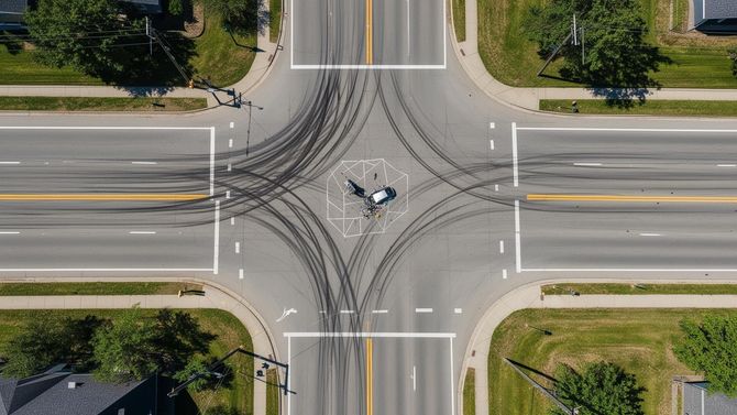
Skid marks fade. Vehicles move. Weather changes. Within hours, the most important evidence is gone forever.
Witnesses see it differently.
Memory shifts. Stories change. Without a clear, unbiased aerial record, your case relies on what people think they remember.
Cases are won at the scene.
Juries respond to what they can see. Aerial Evidence Deliverable imagery turns abstract testimony into undeniable visual fact.

"On scene in under two hours. The footage was exactly what we needed at deposition."
— Panhandle Trial Attorney
YOUR GUIDE
We've spent years documenting what others miss.
American Drone Team is a veteran-owned, FAA Part 107 certified aerial documentation firm built specifically for the legal and insurance community. We don't shoot weddings. We don't shoot real estate listings. We document scenes — the kind that decide cases.
Aerial Evidence deliverables with chain-of-custody documentation
Survey-grade orthomosaic mapping with measurable accuracy
Discreet, professional conduct on active and sensitive sites
Local pilots — fast deployment across the entire Panhandle
The PLAN
Three steps. No guesswork.
Call or Request
Reach us 7 days a week. Tell us where, when, and what you need documented.
We Deploy Fast
FAA-certified pilots are dispatched to capture the scene before evidence is lost.
You Receive Aerial Evidence Files
High-resolution imagery, video, and orthomosaic maps — delivered ready to use.
WHAT WE DO
Specialized aerial documentation built for the legal community.
Every deliverable is captured with care, processed cleanly, and prepared for the standards of court, insurance, and expert review.
Accident Scene Documentation
Rapid-response aerial coverage of roadway conditions, vehicle positioning, and scene context immediately after an incident.
Investigation Support
Detailed aerial documentation supporting investigations with clear, unbiased visual records.
Orthomosaic Mapping
Survey-grade aerial maps delivering accurate, measurable imagery for analysis and reporting.
Sightline & Environmental
Aerial visuals capturing visibility, obstructions, and environmental factors impacting the scene.
Construction Progress
Ongoing aerial documentation tracking site progress, milestones, and project conditions over time.
Aerial Photography & Video
High-resolution imagery and video for reporting, marketing, and site analysis.
WHERE WE FLY
Local pilots. Panhandle-wide coverage.
We're based in the Florida Panhandle and built to deploy fast. If your scene is here, we can be in the air today.
Fort Walton Beach
Destin
Pensacola
Naverre
Niceville
Crestview
Panama City
Gulf Breeze
Milton
Santa Rosa Beach
Pace
Mary Esther
TRUSTED BY
Attorneys, investigators, and insurers across the Panhandle.

"American Drone Team was on scene faster than our investigator. The aerial footage made our intersection-analysis case far easier to argue."
Personal Injury Attorney · Fort Walton Beach

"Professional, clean deliverables, and a pilot who understands what 'Aerial Evidence' actually means. We use them for every major case now."
Insurance Claims Manager · Pensacola
"Their orthomosaic maps gave our expert witness exactly the measurable detail he needed. Worth every penny."
Trial Consultant · Destin
For Attorneys & Investigators
Frequently Asked Questions
Straight answers on deliverables, response times, chain of custody, and how to engage us.
What deliverables do we receive, and in what format?
Every engagement includes high-resolution stills (JPEG + RAW/DNG), 4K video (MP4, H.264), and — when scoped — orthomosaic maps, 3D models, and measured site diagrams. Files are delivered via secure download link with a written flight report, equipment log, & FAA Part 107 certification. Native files are preserved unedited for chain-of-custody.
How fast can you be on scene?
Our average response across the Florida Panhandle is 12-to-24-hour response time in most situations, however, rapid response time can be sooner than 12 hours. We operate 7 days a week, including nights, weekends, and holidays. For active scenes (accidents, fires, weather events), call 850-803-7663 directly — we'll launch as soon as airspace and law enforcement clear us in.
How do you handle chain of custody and authentication?
Original media is hashed (SHA-256) at capture, transferred to write-protected storage, and never altered. You receive the unedited originals plus any annotated working copies, a timestamped flight log, GPS metadata, and pilot credentials. Our pilot is available for deposition or trial testimony as a fact witness.
Are your pilots and aircraft properly certified and insured?
Yes. All flights are conducted by FAA Part 107 Remote Pilots in Command. We carry $1M+ in commercial drone liability insurance and can issue a certificate of insurance naming your firm or client as additional insured on request. Aircraft are registered with the FAA and maintained to manufacturer specifications.
What does it cost, and how is it billed?
Pricing depends on scene complexity, deliverables, and travel. Most accident-scene documentations fall within a predictable flat-rate range; large mapping or multi-day projects are quoted in writing. We invoice firms directly with NET-15 terms or accept card payment. Rush and after-hours dispatch carry a transparent surcharge disclosed up front.
How do I request documentation?
Click "Request Rapid Response" or call/text 850-803-7663. Tell us the location, what happened, and your deadline. We'll confirm scope, ETA, and pricing within minutes during business hours — usually within the hour after-hours. A signed engagement letter and COI follow before launch.
Don't Lose The Scene
The evidence is fading. We're already in the air.
Call or text now for rapid-response aerial documentation across the Florida Panhandle. Available 7 days a week — including weekends, and holidays.
FAA Part 107 · Veteran-Owned · Commercially Insured · Panhandle Local